Map Reading for Orienteering
Contents
- 1 Map Reading for Orienteering
- 1.1 Mastering the Art of Map Reading: A Guide to Orienteering Success
- 1.2 The Importance of Map Reading in Orienteering
- 1.3 Understanding Orienteering Maps
- 1.4 Key Symbols and Features on Orienteering Maps
- 1.5 Basic Navigation Techniques for Orienteering
- 1.6 Advanced Navigation Techniques for Orienteering
- 1.7 Strategies for Efficient Map Reading During Orienteering Races
- 1.8 Tips for Improving Map Reading Skills
- 1.9 Common Mistakes to Avoid in Map Reading for Orienteering
- 1.10 Conclusion and Resources for Further Learning
- 1.11 Orienteering – How to read the Map
- 1.12 Wild Earth
- 1.13 Compass Basics for Orienteering: How to Navigate Like a Pro
Mastering the Art of Map Reading: A Guide to Orienteering Success
Welcome to the ultimate guide on mastering the art of map reading and achieving orienteering success. Whether you’re a beginner looking to navigate the great outdoors or an experienced adventurer seeking to refine your skills, this article is your compass to triumph. With a wealth of knowledge and expertise, we will unlock the secrets of deciphering maps, guiding you through the intricate web of contour lines and symbols.
In this comprehensive guide, we will equip you with the essential tools and techniques to confidently navigate through any terrain. From understanding map legends to utilising compasses effectively, you’ll gain invaluable insights that will elevate your orienteering abilities to new heights. We’ll even explore advanced strategies for efficient route planning, enabling you to conquer even the most challenging courses. Join us on this exciting journey as we delve into the world of map reading and orienteering. Get ready to unlock the power of spatial awareness, boost your confidence in the wilderness, and stride towards orienteering success!
The Importance of Map Reading in Orienteering
Orienteering is a fun and challenging sport that involves navigating through unfamiliar terrain using a map and a compass. It can be done on foot, bike, ski, or even canoe. But no matter what mode of transportation you choose, you need to have good map reading skills to succeed in orienteering.
Map reading is the ability to interpret the symbols, colours, and features on a map and relate them to the real world. It also involves estimating distances, directions, and elevations, and planning the best route to reach your destination. Map reading is essential for orienteering because it helps you:
- Find your location on the map and orient it to the compass
- Identify the landmarks and terrain features that you can use as reference points
- Avoid obstacles and hazards that might slow you down or get you lost
- Choose the most efficient and safe way to travel between the checkpoints
- Monitor your progress and adjust your course if necessary
Map reading is not only useful for orienteering, but also for everyday life. It can help you navigate in unfamiliar places, explore new areas, and appreciate the natural beauty of the world. Map reading can also improve your spatial awareness, problem-solving, and decision-making skills.
So, if you want to enjoy orienteering and improve your map reading skills, here are some tips to get you started:
- Get a good quality map that is accurate, up-to-date, and suitable for your level of difficulty
- Study the map before you start and familiarise yourself with the symbols, colours, and scales
- Use a compass to align the map with the magnetic north and keep it oriented as you move
- Check the map frequently and compare it with what you see around you
- Use the contour lines to understand the shape and steepness of the terrain
- Measure distances and angles using your fingers, thumb, or compass
- Look ahead and plan your route, considering factors such as distance, elevation, terrain, vegetation, water, and weather
- Be flexible and ready to change your route if you encounter unexpected situations or make mistakes
Map reading is a skill that takes practice and patience to master. But once you do, you will find orienteering more enjoyable and rewarding. So, grab your map and compass and head out for an adventure!
Understanding Orienteering Maps
Orienteering is a fun and challenging sport that involves navigating through unfamiliar terrain using a map and a compass. Orienteering maps are different from regular maps in several ways. Here are some tips to help you understand them better.
- Orienteering maps use a standard set of symbols and colours to represent different features of the terrain, such as roads, trails, hills, cliffs, water, vegetation, etc. You can find the meaning of these symbols and colours on the map legend or on the International Orienteering Federation website.
- Orienteering maps are drawn at a larger scale than regular maps, usually 1:10,000 or 1:15,000. This means that one centimetre on the map corresponds to 100 or 150 meters on the ground. This allows for more detail and accuracy on the map.
- Orienteering maps are oriented to magnetic north, not true north. This means that you don’t need to adjust your compass when using the map. You can simply align the north arrow on your compass with the north lines on the map.
- Orienteering maps are updated regularly to reflect changes in the terrain. For example, if a new building is constructed or a forest is cleared, the map will show these changes. However, some minor features may not be shown on the map, such as small rocks, ditches, or fences. You should always use your eyes and common sense when navigating with the map.
Key Symbols and Features on Orienteering Maps
If you’re into orienteering, you know how important it is to read the map correctly. But do you know what all the key symbols and features on orienteering maps mean? Here are some of the most common ones you should know:
- Brown lines: These represent the contours of the terrain, showing the shape and height of the land. The closer the lines are, the steeper the slope. The thicker lines are called index contours and have numbers indicating the elevation in meters.
- Blue features: These are water-related features, such as lakes, rivers, streams, ponds, marshes, and wells. The shape and size of the blue feature indicate how it looks on the ground. For example, a dashed blue line means an intermittent stream that may be dry at times, while a solid blue line means a permanent stream that always has water.
- Black features: These are man-made features, such as roads, trails, buildings, fences, power lines, and bridges. The thickness and style of the black line indicate the type and size of the feature. For example, a thick black line means a major road that is paved and wide, while a thin black line means a minor road that is unpaved and narrow.
- Yellow features: These are open areas, such as fields, meadows, pastures, and clearings. The more yellow the area is, the more open and visible it is. For example, a solid yellow area means an open field with no trees or bushes, while a dotted yellow area means a semi-open area with some scattered trees or bushes.
- Green features: These are wooded areas, such as forests, orchards, and plantations. The greener the area is, the denser and thicker the vegetation is. For example, a white area with green dots means a forest with good visibility and runnability, while a dark green area means a forest with poor visibility and runnability.
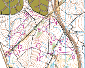
- Purple features: These are special features that are added for orienteering purposes only. They include the start and finish points, the control points, the course line, and any out-of-bounds or forbidden areas. The purple features are usually printed on top of the map after it is made, so they may not match exactly with the underlying features.
These are some of the key symbols and features on orienteering maps that you should be familiar with. Of course, there are many more details and variations that you can learn from studying different maps and practising your skills. Remember to always orient your map to the north using your compass and use both the map and the terrain to navigate your way to success!
Orienteering is a fun and challenging sport that involves using a map and a compass to find your way around a course. You can do it on foot, bike, ski, or even canoe. But before you start, you need to learn some basic navigation techniques that will help you avoid getting lost or going off track.
The first thing you need to do is to orient your map. This means aligning it with the features of the terrain, so that north on the map matches north on the ground. You can use a compass to do this, or you can use landmarks like hills, roads, or streams. Orienting your map will make it easier to identify where you are and where you need to go.
The next thing you need to do is to plan your route. You should look at the map and decide the best way to get from one control point to the next. You should consider factors like distance, elevation, difficulty, and hazards. You should also think about how you will recognise the control point when you get there. Sometimes it might be obvious, like a flag or a sign, but other times it might be hidden or camouflaged.
The last thing you need to do is to execute your route. This means following your plan and checking your map and compass frequently to make sure you are on track. You should also use other navigation skills like pacing, timing, and aiming off. Pacing is counting your steps to measure distance. Timing is using your watch to estimate how long it will take you to reach your destination. Aiming off is deliberately heading slightly left or right of your target, so that when you reach a feature like a road or a stream, you know which way to turn.
These are some basic navigation techniques for orienteering that will help you enjoy the sport and improve your skills. Remember to always carry a map and a compass, and to practice often in different terrains and conditions. Orienteering is not only a great way to exercise your body, but also your mind!
Orienteering is a sport that involves navigating through unfamiliar terrain using a map and a compass. It can be challenging, fun, and rewarding, but it also requires some advanced skills and techniques to do it well. Here are some tips to improve your orienteering performance:
- Plan your route before you start. Look at the map and identify the features, landmarks, and checkpoints that you need to follow. Choose the best route that suits your abilities, preferences, and goals. Avoid unnecessary detours, obstacles, or hazards.
- Use your compass correctly. A compass can help you orient yourself and keep track of your direction. Learn how to use the compass features, such as the needle, the dial, and the baseplate. Align the compass with the map and adjust for magnetic declination. Check your compass frequently and compare it with the map and the terrain.
- Use map-to-ground and ground-to-map techniques. Map-to-ground means looking at the map and then finding the corresponding features on the ground. Ground-to-map means looking at the ground and then finding the corresponding features on the map. These techniques can help you confirm your location and avoid getting lost.
- Use attack points and catching features. Attack points are easily recognisable features that are close to your destination, such as a hilltop, a stream, or a building. Catching features are features that stop you from going too far, such as a road, a fence, or a lake. Use these features to guide you to your target and prevent you from overshooting.
- Use handrails and aiming off. Handrails are linear features that you can follow along your route, such as a trail, a ridge, or a power line. Aiming off means deliberately going slightly to one side of your target, so that you know which way to turn when you reach a feature, such as a junction, a bend, or an edge.
Strategies for Efficient Map Reading During Orienteering Races
Orienteering is a sport that requires you to navigate through unfamiliar terrain using a map and a compass. It can be challenging and fun, but also frustrating if you get lost or waste time. Here are some strategies for efficient map reading during orienteering races:
- Plan ahead. Before you start the race, study the map carefully and identify the features, symbols, colours, and contours that will help you find your way. Mark the checkpoints and the best routes to reach them. Estimate how long it will take you to complete each leg and set a realistic pace.
- Orient the map. Always keep the map aligned with the terrain and the compass. This will help you avoid confusion and mistakes. Use landmarks, such as hills, streams, roads, or buildings, to check your position and direction. Rotate the map as you move and fold it to show only the relevant part.
- Simplify the map. Don’t try to read every detail on the map. Focus on the most important information that will guide you to your next checkpoint. Look for distinctive features that are easy to spot and follow, such as ridges, valleys, trails, or fences. Ignore the minor details that are not relevant or visible.
- Use your peripheral vision. Don’t stare at the map all the time. Look around and observe your surroundings. Use your peripheral vision to scan the map quickly and frequently. This will help you maintain a sense of direction and awareness of the terrain. It will also prevent you from missing any clues or opportunities.
- Trust your instincts. Sometimes, you may feel unsure or doubtful about your map reading skills. Don’t panic or second-guess yourself. Trust your instincts and follow your intuition. If you think you are on the right track, keep going. If you think you are lost, stop and reorient yourself. Don’t be afraid to make mistakes or corrections.
Tips for Improving Map Reading Skills
Map reading is a useful skill that can help you navigate unfamiliar places, plan routes, and enjoy outdoor activities. Here are some tips for improving your map reading skills:
- Learn the basics of map symbols, scales, and orientations. Map symbols are the shapes and colours that represent different features on the map, such as roads, buildings, water, and vegetation. Map scales show how much distance on the map corresponds to the real world, usually in the form of a ratio or a bar. Map orientations show how the map is aligned with the cardinal directions, usually with a compass rose or an arrow pointing north.
- Practice using a compass and a protractor to measure directions and angles on the map. A compass can help you find your bearings and align the map with the real world. A protractor can help you measure the angle between two points or features on the map, which can be useful for estimating distances or finding locations.
- Use landmarks and grid references to pinpoint your position and destination on the map. Landmarks are prominent features that are easy to identify on the map and in the real world, such as hills, bridges, or buildings. Grid references are alphanumeric codes that divide the map into small squares, each with a unique identifier. By using landmarks and grid references, you can locate yourself and your destination on the map more accurately and efficiently.
- Check your map regularly and update your mental picture of the terrain. As you move along your route, you should check your map every few minutes to make sure you are on track and to anticipate any changes in the terrain ahead. You should also update your mental picture of the terrain by comparing what you see on the map with what you see in the real world. This can help you avoid getting lost or confused by discrepancies or errors on the map.
- Have fun and challenge yourself with different types of maps and scenarios. Map reading is not only a practical skill but also a fun activity that can enhance your spatial awareness and problem-solving abilities. You can try different types of maps, such as topographic maps, road maps, or satellite maps, and see how they differ in their information and presentation. You can also challenge yourself with different scenarios, such as finding your way in a new city, planning a hiking trip, or participating in a treasure hunt.
Common Mistakes to Avoid in Map Reading for Orienteering
Orienteering is a fun and challenging sport that involves using a map and a compass to navigate through unfamiliar terrain. But if you want to enjoy orienteering, you need to avoid some common mistakes that can ruin your experience. Here are some tips to help you read a map correctly and avoid getting lost.
- Don’t rely on the colours of the map. The colours on an orienteering map are not the same as the colours on a road map or a topographic map. They are symbols that represent different types of terrain, such as open land, forest, water, etc. For example, white means open forest, green means dense forest, blue means water, and yellow means open land. You need to learn the meaning of these symbols and use them to identify the features on the ground.
- Don’t ignore the contour lines. The contour lines on an orienteering map show the shape and elevation of the land. They are very important for finding your location and choosing the best route. You need to pay attention to the spacing, direction, and shape of the contour lines. For example, close contour lines mean steep slopes, parallel contour lines mean flat areas, and curved contour lines mean hills or valleys.
- Don’t forget to orient your map. Orienting your map means aligning it with the direction of north on the ground. You can use a compass or natural features like the sun or stars to do this. Orienting your map helps you match the features on the map with the features on the ground. It also helps you keep track of your direction and avoid turning the wrong way.
- Don’t lose contact with your map. Losing contact with your map means losing track of where you are on the map and where you are going. This can happen if you move too fast, look at your surroundings too much, or get distracted by other things. To avoid losing contact with your map, you need to check it frequently and compare it with what you see on the ground. You also need to use techniques like thumbing, which means keeping your thumb on your current location on the map, or aiming off, which means deliberately choosing a point slightly off your intended direction so that you know which way to turn when you reach it.
- Don’t panic if you get lost. Getting lost is not uncommon in orienteering, especially for beginners. But panicking will only make things worse. If you get lost, you need to calm down and try to relocate yourself on the map. You can do this by looking for distinctive features on the ground that match the features on the map, such as roads, streams, buildings, etc. You can also use your compass to find north and align it with north on the map. If you still can’t find yourself on the map, you can backtrack to a known point or ask for help from other orienteers or officials.
Conclusion and Resources for Further Learning
You’ve learned the basics of orienteering map reading, but there’s still a lot more to explore. Orienteering is a fun and challenging sport that can take you to amazing places and test your skills. Whether you want to compete in races, go on adventures, or just enjoy nature, orienteering can offer you a rewarding experience.
If you want to learn more about orienteering, here are some resources that can help you:
- The International Orienteering Federation (IOF) website (https://orienteering.sport/) has information about the rules, events, and news of orienteering around the world.
- Orienteering Australia (https://orienteering.asn.au/).
- The Orienteering USA website (https://orienteeringusa.org/).
- British Orienteering (https://www.britishorienteering.org.uk/).
We hope you enjoyed this guide and that you’ll continue to practice and improve your orienteering map reading skills. Remember to always be safe, respectful, and responsible when you’re out in the woods. Happy orienteering!
Pingback: Compass Basics for Orienteering: How to Navigate Like a Pro